Showing posts with label Desolation Wilderness. Show all posts

Thursday, October 02, 2014

Summer Summary


It's raining in Truckee!! Hallelujah. (Okay, it was raining when I started this post. That was last weekend. But the sentiment is the same.)

I'm not just grateful for rain because of this insidious drought, but also because of that nasty King Fire. The smoke in Tahoe has been stifling the last two weeks, and folks down the hill have had to evacuate. 

Fall feels a bit in the air, and with that happy fact, I am reminded to make my usual summer wrap-up post. I may be a complete bloggging slacker, but at least I have my traditions.

Unfortunately, the short summary for this summer goes like this:

It was completely shitty.

An accurate and succinct summary, if a bit lacking on details. But truthfully, I'm tired of giving the details. 

Last weekend, my husband and I visited with some friends we hadn't seen in four or five months. I came straight out and told the wife in the couple that I was tired of updating people on the upsetting events of my life, so could we just skip the "What's been happening in your life?" question? 

She replied, "Let's just talk about trail running!"

Now that is a good friend.

So for this post, I'm going to skip all the shitty parts. I can't ignore them, but I guess I don't have to relive them here. Instead, I thought I would take this opportunity to focus on all the awesome parts of this summer.

Because you know what? Even among all the challenges - the feelings of betrayal, the injustices, the immense grief - there were still some pretty awesome things that happened this summer. Reminding myself of these things is one good way of dealing with the challenges - keeping perspective, and realizing that even a shit sandwich doesn't taste as bad when you're sitting by a mountain lake with a cocktail in hand. (Okay, I'm sorry, I will stop swearing now. Terribly embarrassing, my crassness.)

So. Awesome parts of this summer, in chronological order:


Hangin' at Western States


For the first time in several years, I was neither volunteer, runner, nor pacer. I thoroughly enjoyed geeking out as a fan.


Gary Gellin nears the top of the Escarpment.

And the finish line especially. Always a social, and very emotional place to spend time.


The Trent girls await the leader at Placer High.


See what I mean about emotions? (Pictured: Rob Krar)

More emotions! Yay! (Pictured: Max King)


Fourth of July!

The fourth is always awesome in Truckee, and this year was no different. Good friends, perfect weather, parades, swimming, barbecues, bike rides, tubing down the river. Fun!


The Dream Team at the Truckee Parade.


Family Visits

Fishing day with the boys!

Game time: "I am a Pig." "I am a Camel." (Not the most flattering pic, but certainly the funniest!)


TRT 50K

Due to the fact that I spent most of June and the first part of July injured, I dropped down from the 50M distance I'd signed up for and ran the 50K (actually 55K) at TRT for the first time since 2003. Oh wow! I think I like the 50K. No Diamond Peak climb, and it's over so fast! Plus, I won. Total bonus.

And I will tell you that staying up all night to volunteer at the Tunnel Creek AS is much easier with only 55K on your legs vs. 50M. Just as much fun though!


Pre-race with the RD


TRT 173

It seems like a lot of my adventures involve the Tahoe Rim Trail, but this one was truly unique. Five runners, four days, and 173 miles of jaw-dropping scenery. 

I don't want to say too much about this one, since I SWEAR I AM GOING TO WRITE A REAL POST ABOUT IT. I promise. I am.

But the summary is that it kind of turned out to be the gem of the summer. Two of our really big challenges were already upon me and my husband, and a third was just hitting the fan when this adventure began. I didn't know if I should even be out there on the trail for so many reasons, but it turned out to be the best decision I could have made.

I am massively grateful for the friends who put in all of the work to plan this adventure and who turned out to be amazing people with whom to share the trail!


173 Miles that looked something like this

Triumphant at the end of our journey: Me, Chris, Tyler, Curt, and Joe. (And Sierra Nevada Pale Ale.)


A New Kitchen

This is another one that I am not going to give all the details on because I really want to do a full post with before and after pictures. There was quite a process, and it looks amazing, but of course, it's still not done. (Started in April, why would we be done by October?) As soon as the back splash and trim are in, there will be lots of pictures! Pinky swear.


Here's Andrew on concrete day. This doesn't show you anything about our kitchen, does it? But just wait until you see the killer concrete counter tops he made me!!


Other Adventures

Of course there were plenty of beautiful trail miles shared with friends, (several times getting caught out in hail and lightning), and other "daily" adventures. In completely non-chronological order:


Hoover Wilderness and Yosemite with Jamie:


Jamie

Happy in the mountains

Alpine lake in the Hoover Wilderness


Running near home:


Castle Peak, Donner Summit

Desolation Wilderness with Betsy


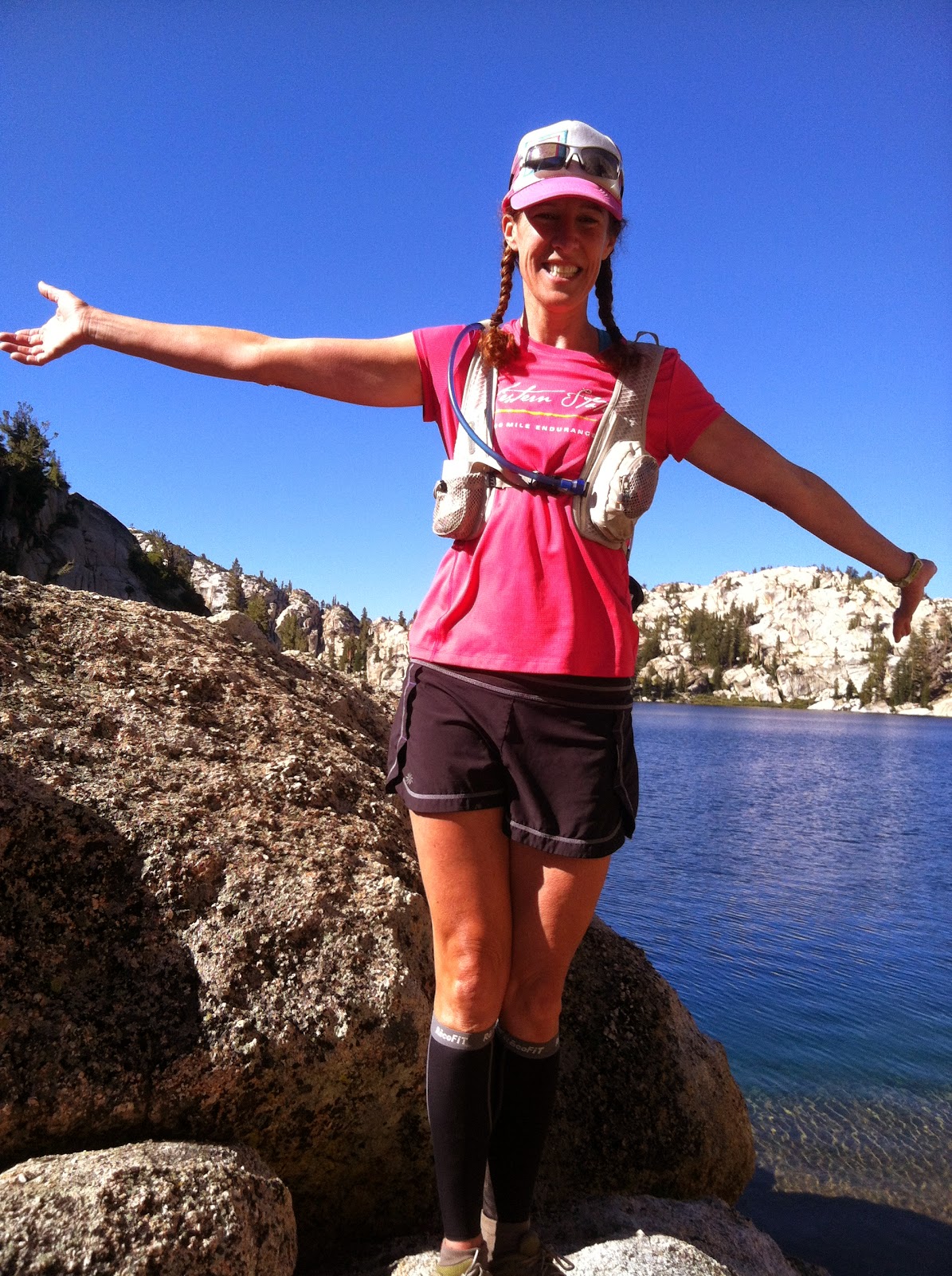
Aloha Lake/Desolation Wilderness with Jamie and Caren


Jason's wedding with the college track crew (no running involved).


I know this was mostly a post in pictures. I don't have a lot of words these days. Honestly though, I'm hoping to find some. I miss writing.

Last summer, my sister declared it to be The Summer of Joy. We did so many wonderful things with family, knowing that with my mom's ALS diagnosis, it would be the last summer with her in good health. It truly was wonderful - three full months of family time up and down the coast.

This one was declared The Summer of Sadness. Aptly named, and thankfully in the rearview mirror.

My sister has already declared next summer to be The Summer of Healing. I'm assuming that means more family trips, and I'm all for that! In fact, I'm pretty much ready for summer right now.


Monday, August 20, 2012

Bayview Trail / Rockbound Valley Loop - Desolation Wilderness


Trail: Highly Technical Singletrack

Distance: 26 miles, 5,220 ft elevation gain

Difficulty: Challenging

Trailhead: From Tahoe City, take Highway 89 south for about 30 minutes to Emerald Bay. About a mile past the Eagle Falls trailhead, find the Bayview trailhead on your right, across from Inspiration Point. Drive through the campground to the trailhead parking.

From South Lake Tahoe, take Highway 89 north for about 10 minutes to Emerald Bay. Find the Bayview trailhead on your left across from Inspiration Point. Drive through the campground to the trailhead parking.

Season: July to October

Water: Water is available in the campground at the trailhead. There are numerous streams and lakes throughout the run. Late season, the streams may be dry and you'll need to rely on lakes.

Notes: Wilderness permits are required and can be filled out for free at the trailhead. 

Trail Description: First, you should consult a map, which can be found online here. My overview does not explain every turn at every trail juncture, but you should be able to follow my route description with use of the map.

Start at the Bayview Trailhead and climb the forested switchbacks for 2-3 miles.


The namesake bay view of Emerald Bay.


Follow the next several trail junctions downhill to the Velma Lakes, and eventually to the trail through Rockbound Valley. Watch for cairns to help keep you on course through this rocky section of trail.


The trail, marked with rocks across stretches of granite slabs.

Take a left, heading south, on the trail through Rockbound Valley toward Mosquito Pass. In spite of the name, this stretch provides some of the most runnable miles of trail.


Running through Rockbound Valley.


 Climb up Mosquito Pass ...


... and down into the Aloha Lakes Basin.


Descending to Aloha Lakes


From Aloha, take the PCT/TRT west along Heather and Susie Lakes.


Heather Lake


Continue following the PCT and TRT north over Dick's Pass.


Climbing Dick's Pass


At the top!


Leave the PCT/TRT before reaching Fontanillis Lake, and head east back to the Bayview Trail. When you can see the big lake over the tree tops, you know you're close. Descend all the way back to the trailhead.


This is an incredibly challenging but rewarding 26 miles. Be sure to give yourself plenty of time, as the technical aspects to trails in Desolation make for slow going. Don't forget to bring a camera!


Saturday, December 31, 2011

When There's no Snow in a Ski Town


It’s a glum aura hangs around this mountain town. December has come and gone (okay, almost) with nary a bit of the white stuff. We did not have a white Christmas. Already minimal operations at ski resorts are shrinking even further, kindling a firestorm of layoffs. No one is stoked.

Except for the trail runners.

In stark contrast to last year’s winter where I’d already had two months of backcountry powder glory on my skis by this point, we’re still running high country trails. It does a bit to make up for the fact that many trails didn’t open up until August last summer.

Is this what it’s like to live somewhere where it doesn’t snow? I’m in the best shape I’ve ever been in for December.

And what do the ski bums do (besides shed a tear in their whiskey over their state of unemployment) when there’s no snow? Well, mountain biking is the obvious choice, and there’s plenty of that going on. Ice climbing conditions are better than they’ve been in a decade, but that only appeals to a select group of nut cases. I gave that up when I left Minnesota! You know what’s really all the rage in the Sierra right now?

Ice skating.


Frozen Echo Lake

Usually by the time it’s cold enough for anything to freeze, it’s all buried under 20 feet of snow. But people have been making the best of an unusual winter, and the skating is off the hook. I mean, have you seen any of those pictures of people skating on Tenaya Lake in Yosemite? How can you not want to skate across that glassy expanse surrounded by massive granite domes? I am not much of a skater, but to glide across the ice in an empty, beautiful, wilderness is pretty special.

There are four or five good lakes to skate in Truckee right now, but those Yosemite pictures I saw online really captured me. I wanted to skate the backcountry.

And who could I get to join me on a trail running/ice skating Desolation Wilderness adventure in late December? I knew before I asked that Jamie would come along for the ride – that girl is addicted to those trails.

She and Anthony joined me on Friday for a 12 mile run out to Lake Aloha, although I was the only goofball with ice skates strapped to my hydration pack.


Dear GoLite pack, you have passed the test. You're going to Hardrock, baby!

We all agreed that there was less snow than there had been out on that trail in July, and the amount of running we were able to do was wonderful.


There was still a bit of ice on the trail in places though.


We did hit some snow within about a mile of Aloha, but it was still incredibly reasonable running.


The skating on Aloha wasn’t quite the Tenaya Lake glory that I had envisioned. (There is WAY less water up there this time of year.) Although the actual skating in Truckee is better, the novelty of being out there sliding around on the ice was totally worth bringing the skates. So much fun!


Demonstrating exceptional skating technique.


This entire winter break has been somewhat of a novelty for me. My mileage has been fueled a bit by some anxiety over this 100 mile race I’ll be doing in July, but mostly it’s just been a matter of opportunity. When I think about the places I’ve run in the last four days, I can’t help but smile. Four completely different runs, in different weather and conditions. I’m blown away by the running available right now, and I’m taking advantage of every single bit.


Tuesday: Donner Lake, 10 miles on road, starry skies, 11 degrees F


Wednesday: Peavine, 14 miles on dirt, 4,000' vert, partly cloudy, 60 degrees F


Thursday: Desolation Wilderness, 12 miles on technical trail and snow, partly cloudy, 37 degrees F


Friday: Michigan Bluff to the swinging bridge and back, 21 miles on trail, light rain, 46 degrees F


Friday, October 28, 2011

Mt. Tallac Trail, Desolation Wilderness


Trail: Technical Singletrack

Distance: 22 miles, 6500' elevation gain (trailhead to Lake Aloha and back)

Difficulty: Challenging

Trailhead: The Mt. Tallac trailhead is reached via Highway 89 near South Lake Tahoe. Traveling from the west shore, look fir the brown trailhead sign on the right, just past Camp Richardson. Follow the paved road to the parking area for Mt. Tallac.There are no bathrooms or water available at this trailhead.

Season: July to October

Water: The upper slopes of Mt. Tallac are dry, but otherwise, streams and lakes are abundant throughout the run.

Notes: Wilderness permits are required. There is no fee, and permits can be filled out at the trailhead.


Trail Description: The climbing on this trail doesn't mess around, and we began gaining altitude immediately. I set off on the forested trail with Betsy, Jamie, Caren, Jenelle and three dogs. We were layered up on this crisp fall morning, but soon stopped to shed jackets and sleeves as the exercise and sunshine brought color to our cheeks. 


We didn't get into Desolation Wilderness until early August this year because of all the snow, and I think somehow that's given me a greater appreciation for these incredible autumn days on the trail. Every mile before the snow flies feels like a gift. 

If you sniff deep into the cracks of the bark, it smells like sweet vanilla. Mmmmm!


As we climbed higher, we finally left treeline behind. Following the switchbacks up, we were treated with expanding views of the lake below.


 Upon reaching the shoulder of Mt. Tallac, you can look out to see the granite ridge that rises above Lake Aloha, our eventual destination.


 At the spur trail, we headed towards the summit for a quick trip to the top.

Cap is not afraid to stand near the edge.

At the top: Caren, Jamie, Jenelle, me, with Betsy behind the camera.


Tallac is one of the tallest peaks around, and we spent a few minutes enjoying the views and snapping photos. It was surprisingly warm for late October, and we all felt lucky to be out on such a beautiful day.

After returning along the spur trail, we rejoined the main trail and continued down the other side of the mountain toward Gilmore Lake.


Betsy and Caren head down towards Gilmore Lake.


At Gilmore, we joined the Pacific Crest Trail and headed south towards Aloha. Jamie and Caren were doing a one-way run to the Glen Alpine trail, so we soon bid them farewell.

We skirted Susie and Heather lakes, where I decided to skip the final mile to Aloha in lieu of a rest. I hadn't been feeling well all morning, and a mental break seemed like just the thing I needed. Cap and I stretched out in the sunshine by the lake while Betsy and Jenelle ran off to tag Aloha. It seemed I had the entire wilderness to myself, and the stillness in both my body and my environment did wonders to soothe my mind.


The return trip over the mountain was somehow even more glorious. I felt better, stronger. There were more hikers out now that we again neared the trailhead, and they all kindly yielded to us. The downhill felt easy, in spite of the long day, and the miles back to the car seemed to melt away.

We drove back to Truckee, three tired and happy runners.